Losing a drone can be a heart-stopping moment for any pilot, whether you’re a seasoned professional or a weekend hobbyist. One moment, your drone is soaring through the sky, capturing breathtaking views, and the next, it’s out of sight, potentially lost forever. This frustrating experience is unfortunately common, often due to signal loss, battery failure, or simply misjudgment. But don’t despair! With the right strategies, tracking tools, and a systematic approach, you can significantly increase your chances of reuniting with your valuable aerial companion. This comprehensive guide will equip you with proven methods and essential insights to track down and recover your lost drone, minimizing stress and maximizing your success.
Understanding Why Drones Get Lost
Before diving into recovery tactics, it’s crucial to understand the common culprits behind drone disappearances. Knowing these factors can not only help you in your search but also prevent future incidents.
One primary reason drones get lost is signal loss or interference. This can occur when flying beyond the drone’s operational range, encountering electromagnetic interference from structures like cell towers, or simply due to obstacles between the remote controller and the aircraft. When the connection severs, the drone may execute its programmed “lost signal” behavior, such as attempting to return home, hovering, or landing, but not always successfully.
Another frequent cause is power source failure or a depleted battery. Most drones have real-time battery indicators and will attempt to initiate a return-to-home (RTH) sequence when power runs low. However, unforeseen factors like strong winds, extended flight distances, or a neglected battery can cause the drone to run out of charge mid-flight and crash land unexpectedly.
Furthermore, hardware or software malfunctions can lead to erratic flight behavior or sudden crashes. Even advanced drones equipped with obstacle avoidance sensors can sometimes fail to detect thin objects like power lines or reflective surfaces like water or glass, especially in poor lighting conditions. Pilot error, such as flying in hazardous weather or misjudging distances, also contributes significantly to drone loss.
Immediate Steps After Losing Your Drone
When your drone disappears from sight or loses connection, panic is a natural reaction. However, a calm and methodical response in the initial moments can be the difference between recovery and permanent loss.
First and foremost, stay calm and mentally retrace your drone’s last known flight path. Try to remember the last visual you had or the last point it appeared on your screen. Immediately check your remote controller and flight app for any last known GPS coordinates or telemetry data. Many popular drone apps, like DJI Fly, DJI GO 4, and Airdata, record this information, providing a crucial starting point for your search.
If your drone still has battery life and the connection briefly re-establishes, initiate the Return-to-Home (RTH) function if you haven’t already. While the video feed might be gone, the control signal may still be active on a different frequency, allowing the drone to attempt to fly back to its pre-set home point. For FPV pilots, reviewing your onboard DVR (Digital Video Recorder) footage can offer critical clues about the drone’s final moments and trajectory, helping you narrow down the potential crash site. Crucially, keep your controller turned on as you approach the suspected area; if the drone regains power or signal, your controller might pick it up, providing valuable telemetry data even without GPS.
Leveraging Onboard Tracking Features and Apps
Modern drones are equipped with sophisticated technology designed to assist in locating them, and understanding these features is paramount for a successful recovery.
The most powerful tool at your disposal is often the drone’s built-in GPS tracking. Many drones continuously log their flight path and last known position. Apps such as DJI Fly, DJI GO 4, and Airdata UAV provide this invaluable data, allowing you to view your drone’s last recorded location on a map. Once you have these coordinates, you can input them into third-party map services like Google Maps, Apple Maps, or Google Earth to get a clear visual of the search area and plan your ground route. However, it’s important to remember that these apps typically provide the last known location, not real-time tracking, especially if the drone has crashed or its battery is dead.
Beyond GPS coordinates, many drone manufacturers offer a “Find My Drone” feature within their proprietary apps. For instance, DJI’s “Find My Drone” allows you to activate flashing LED lights and a beeping sound on the aircraft, provided it still has battery power and can reconnect to the remote controller. This audible and visual signal can be incredibly helpful when you are close to the drone but can’t quite pinpoint its exact location in dense foliage or difficult terrain. Checking the image information from the moment of disconnection, if available in your flight app, can also provide visual cues to determine the crash site.
Specialized Drone Tracking Tools
While integrated app features are a great starting point, dedicated tracking tools can significantly boost your recovery efforts, especially when a drone loses all power or connectivity.
For pilots whose drones might not be equipped with robust GPS or for those seeking extra layers of security, dedicated RF (Radio Frequency) trackers can be a game-changer. These small, lightweight devices attach to your drone and emit a radio signal that can be picked up by a handheld receiver. Products like Loc8tor or tBeacon (mentioned in earlier search results) are examples of such RF-based lost model finders [cite: 4 in initial search results]. They work even if your drone’s main battery dies, as they operate on their own power source, guiding you to the drone’s precise location through signal strength indicators.
Another approach involves DIY tracking solutions, such as attaching popular Bluetooth trackers like Tile or Apple AirTag to your drone. While these are not specifically designed for drones, their widespread network can help locate a lost drone within a certain range or if it’s found by someone else with the corresponding app. However, their limitations include battery life, range, and dependence on other devices being near the lost drone to update its location. For drones without GPS, IMU (Inertial Measurement Unit) technology can also be leveraged. IMUs monitor drone movement using accelerometers and gyroscopes, allowing for position tracking even in areas without GPS signals or high electromagnetic interference. Analyzing this data can help determine the drone’s last direction of flight before contact was lost.
Effective Ground Search Strategies
Once you have a general idea of your drone’s last known location, transitioning to an organized ground search is crucial. This phase requires patience, persistence, and a methodical approach.
Start by mapping out your search area. Using the last known GPS coordinates from your flight app, define a perimeter and begin your search from the center, gradually expanding outwards. For optimal coverage, employ systematic search patterns such as circular sweeps or parallel lines. This ensures you cover the entire suspected area thoroughly and avoid missing crucial spots. When searching, especially in tall grass or dense undergrowth, walk slowly and methodically, scanning every potential hiding spot.
Equip yourself with appropriate visual aids. Binoculars or a telescope can help scan distant trees or rooftops from the ground. If searching at night or in low-light conditions, powerful flashlights are essential. The drone’s built-in flashing LED lights, if activated, will be much easier to spot in the dark. For advanced searches, especially at night, consider using a thermal camera or night vision goggles, as the drone’s residual heat might be detectable. When the drone is located but inaccessible (e.g., stuck in a tall tree or on a rooftop), physical retrieval tools like ladders, long sticks, or specialized drone recovery kits (featuring hooks, ropes, or magnets) can be invaluable. While metal detectors might seem like a good idea, they are generally ineffective unless you are directly on top of the drone due to their limited range and the small amount of detectable metal in most drones [cite: 3 in initial search results].
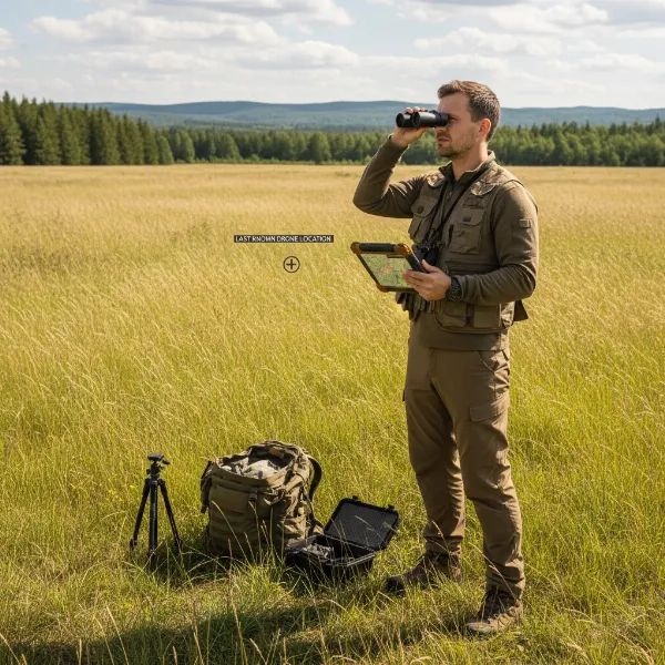 Drone pilot using a tablet to view flight logs while searching for a lost drone in a grassy field with binoculars
Community Assistance and Reporting
Sometimes, despite your best efforts, a drone remains elusive. In such cases, leveraging community resources and official channels can significantly improve your chances of recovery.
If your drone is lost in a populated area, local outreach is a powerful tool. Don’t hesitate to ask neighbors or property owners if they’ve seen or heard anything unusual or if a drone might have crashed on their land. Social media platforms, particularly local community groups or drone enthusiast forums, can be excellent places to share information about your lost drone. Provide a detailed description, the last known location, and a photo of your drone. Consider printing and distributing posters in the vicinity of the loss, and for added incentive, offer a reward for its safe return.
It’s also advisable to file a report with local law enforcement. While they may not actively search for your drone, they can keep an eye out for any recovered drones or incident reports. Similarly, if your drone has unique identifiers, such as a serial number, contacting the drone manufacturer (e.g., DJI) can be beneficial. If someone finds your drone and contacts the manufacturer with the serial number, they might be able to facilitate its return to you [cite: 5 in initial search results]. This creates a passive recovery network that can pay off over time.
Preventative Measures to Avoid Future Drone Loss
The best recovery strategy is prevention. By adopting diligent pre-flight routines and smart flying practices, you can drastically reduce the likelihood of losing your drone in the first place.
Before every flight, conduct thorough pre-flight checks. This includes ensuring your drone’s battery is fully charged and securely seated, checking propellers for any damage, verifying that GPS has a strong signal lock (ideally four bars or more), and confirming that firmware is up to date. A stable GPS signal is critical for features like Return-to-Home to function accurately.
Careful flight planning is equally important. Always be aware of your surroundings, potential obstacles, and current weather conditions. High winds are a common cause of flyaways and can quickly deplete battery life. Always fly within your visual line of sight (VLOS), as mandated by many aviation authorities. Relying solely on a live video feed can lead to disorientation and loss of peripheral vision. When you change your take-off location, remember to update your Home Point in the app; the drone will only return to the last designated Home Point. Setting an appropriate RTH altitude is also vital, ensuring your drone ascends above potential obstacles like trees or buildings before returning home. Lastly, for an added layer of protection, consider attaching a physical label with your contact information directly onto your drone. This simple step can greatly facilitate its return if found by a Good Samaritan.
“Preparation is key. A few minutes spent on pre-flight checks and proper RTH settings can save you hours of searching and the cost of a new drone.” – Jane Doe, Certified Drone Instructor
Conclusion
Losing a drone can be a daunting experience, but it’s not always a permanent one. By understanding the common causes of drone loss and implementing a systematic approach, your chances of a successful recovery are significantly enhanced. From leveraging the powerful GPS tracking features within your drone’s flight app to employing methodical ground search strategies and engaging with your community, every step you take contributes to reuniting with your lost aircraft. Remember, while recovery tools and methods are invaluable, the most effective strategy lies in prevention through diligent pre-flight checks, responsible piloting, and proactive measures like labeling your drone. Invest in these practices, and you’ll not only safeguard your equipment but also elevate your overall drone flying experience.
What steps will you take to prevent future drone losses and ensure you’re prepared for any eventuality?
Frequently Asked Questions
Can I find my drone if its battery is dead?
|
Our Picks for the Best Drone in 2026
As an Amazon Associate I earn from qualifying purchases.
|
||
| Num | Product | Action |
|---|---|---|
| 1 | DJI Mini 4K Camera Drone Combo, Drone with 4K UHD Camera for Adults, Under 249 g, 3-Axis Gimbal Stabilization, 10km Video Transmission, Auto Return, 2 Batteries for 62-Min Max Flight Time, QuickShots |

|
| 2 | GPS Drones with Camera for Adults 4K, FPV Drone Under 249g with Brushless Motor, GPS Auto Return, Follow Me, Circle Fly, Waypoint Flight, Foldable Drone with Gesture Control, 46Mins with 2 Batteries |
|
| 3 | Drone with 1080P Camera - Foldable Remote Control Quadcopter with Gesture Control, 3D Flip, One Key Start, Emergency Stop, 2 Batteries, Easier to use, Toy for Kids Adult Beginners |
|
| 4 | Drone with Camera for Adults 4K, Brushless Motor Drones for Kids Beginners, 60 Mins Flight, 130° Lens, FPV Foldable RC Quadcopter, Gesture Photography, Toys Gifts for Teen Boys Girls, Black |
|
| 5 | Drone with Camera, Drones for Adults and Beginners, 1080P HD FPV Foldable Mini Drones for Kids, with 2 Batteries, Carrying Case, Trajectory Flight, Gravity Control, One-Key Takeoff/Landing, 360° Flip, Toys for Gift |
|
| 6 | Drone with Camera 1080P HD FPV Foldable Mini Drone for Beginners Kids Adults, Drone with One Key Take Off/Landing, Gesture Selfie, Altitude Hold, 3D Flip, Easy to Fly, 2 Batteries, Toys for Boys Girls |
|
| 7 | Drone with Camera - Drone with Screen on Controller for Beginners, Foldable Remote Control Quadcopter with Gesture Control, 3D Flip, One Key Start, Emergency Stop, 2 Batteries, Easier to use to use |
|
| 8 | DJI Mini 4K, Drone with 4K UHD Camera for Adults, Under 249 g, 3-Axis Gimbal Stabilization, 10km Video Transmission, Auto Return, Wind Resistance, 1 Battery for 31-Min Max Flight Time, Intelligent |
|
| 9 | DJI Air 3S Fly More Combo (RC 2 Screen Remote Controller), Drone with 1" CMOS Wide-Angle & Medium Tele Camera for Adults, 4K/60fps, Omnidirectional Sensing & 3 Batteries for Extended Flight Time |
|
| 10 | DJI Mini 3 Fly More Combo (DJI RC), Drones with Camera for Adults 4K, 3 Batteries for 114-min Flight Time, Vertical Shooting, 32800ft (10km) Video Transmission, Lightweight Mini Drone for Beginners |
|
Finding a drone with a dead battery is more challenging but not impossible. The “Find My Drone” feature or beeping functions won’t work, but the flight app should still provide the last known GPS coordinates before the battery died. This location is your primary starting point for a manual ground search, potentially aided by external RF trackers if you had one installed.
What if my drone doesn’t have GPS?
If your drone lacks GPS, locating it relies heavily on manual search efforts. You’ll need to meticulously scan the area where you last saw it or where you suspect it crashed. Reviewing FPV footage or using IMU data for directional insights can help, and systematic search patterns are crucial for thorough coverage. Consider attaching a third-party RF tracker for future flights.
How far can a lost drone be tracked?
The range for tracking a lost drone depends entirely on the technology used. Onboard GPS systems provide the last known coordinates regardless of distance, but real-time tracking through apps is limited by the drone’s connection range to the controller. Dedicated RF trackers can extend tracking capability for several miles, while Bluetooth trackers have a much more limited range, often only a few hundred feet, relying on passing devices to update location.
Is drone insurance worth it?
Drone insurance is often a wise investment, especially for expensive models or commercial operators. It can cover the cost of repairs or even replacement in case of damage, theft, or irreversible loss. While it doesn’t help you physically find your drone, it provides financial peace of mind, mitigating the monetary impact of a lost aircraft.
What’s the best drone tracker?
The “best” drone tracker depends on your drone and flying habits. For most modern drones, the built-in GPS and flight app features (like DJI’s “Find My Drone”) are often the first and most effective tools. For added security, especially if flying in remote areas or with FPV drones, a dedicated, self-powered RF tracker (like a lost model beeper or specialized RF locator) offers robust tracking even after a power loss [cite: 3, 4 in initial search results].